Conférence par Jean-Claude Robert
Professeur émérite, Département d’histoire, UQAM
Lire l’article de Jean-Claude Robert sur ce thème
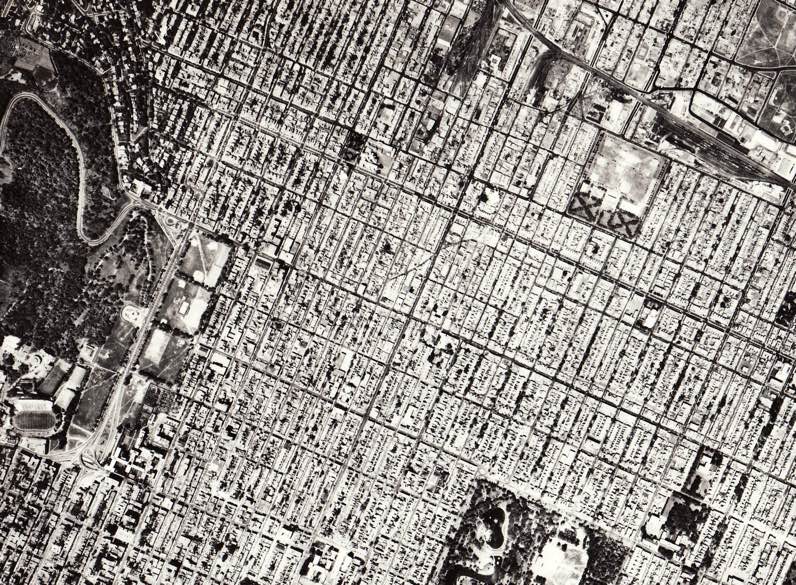
Canada, Photothèque nationale de l’air, Montréal 1965, cliché A 18763-150 (1:20000)
Qu’est ce qu’un quartier ? Un territoire, bien sûr, mais qui ne se résume pas nécessairement à un seul espace géographique; il peut être aussi le produit d’une succession de communautés, sources d’identités plurielles. Le cas du Plateau Mont-Royal est exemplaire à cet égard : villages, paroisses et quartiers très typés se sont succédés avant la création du conseil d’arrondissement au début des années 2000.
Le «Plateau» est-il aussi une fiction créée par des auteurs comme Mordecai Richler et Michel Tremblay ? Mais si la fiction contribuait également à créer la réalité ?
Jean-Claude Robert, spécialiste de l’histoire montréalaise, est l’auteur de l’Atlas historique de Montréal et l’un des co-auteurs de l’Histoire du Québec contemporain en deux volumes : De la Confédération à la crise et Le Québec depuis 1930.
- Dimanche 25 janvier 2015, de 14 h à 16 h
- Bibliothèque du Mile End, 5434 avenue du Parc, Montréal (au sud de Saint-Viateur – autobus 80) – dans la salle de réunion à l’étage
- Gratuit, sans inscription
- Conférence en français, discussion en français et en anglais
I certainly hope to be at M. Robert’s presentation. A rather mundane question in my mind is re the division of the east side of Hutchison being in Montreal and the west side where I live being in Outremont! Why is the dividing line in the middle of our street? Which I gather to be so from the civic services! The history behind this division, albeit trivial, interests me
Good evening Gordon – We will be pleased to meet you on Sunday!
In answer to your question, the municipal border at Hutchison Street was established along a rural property line in 1846, during the first wave of municipal incorporations in Canada. Although many of the municipalities then set up were abolished in short order and new ones were created some years later, this particular borderline has always remained in place. Even before 1846, the limit between the concessions of Côte Sainte-Catherine and Coteau Saint-Louis had been placed here by the Sulpicians; it’s a border with a long history.
The question then becomes: why was Hutchison Street laid out right along the municipal border in 1890? The real estate developers responsible for this street layout – Torontonians with the unlikely names of Clarence James McCuaig and Rienzi Athel Mainwaring – had bought a strip of land six arpents (about 1150 English feet or 350 m) wide straddling the municipal border, two arpents in Outremont and four in Saint-Louis-du-Mile-End, running between what are now Fairmount Av. and Saint-Zotique St. They wanted to create the greatest possible number of uniformly-sized building lots of about 50 x 100 feet, and thus calculated the optimal placement of four parallel streets (Spadina, now Durocher; Madison, now Hutchison; Park; and Admiral, now Jeanne-Mance), 60 feet wide except 80 feet for Park Av., and three 20-foot lanes. If you do the calculation you’ll find that Hutchison St. ends up along the eastern side of the municipal border, with the lots on the west side of the street in Outremont. For the same reason, Park Av. had to be moved slightly westward from its previous alignment, creating the bend in the road just north of Fairmount Av.
The rest of the story of this real estate project called Montreal Annex and the ups and downs of McCuaig & Mainwaring will appear later this year on this site, in an article by Yves Desjardins.