Chapitre 3 – Mile End and its major landowners, part 1. The Bagg family and John Clark
The Baggs and the Beaubiens. For several generations, these well-known Montreal families, one English-Canadian, the other French-Canadian, were major property holders and neighbours. They played an essential role in the transformation of a rural space into an early Montreal suburb. This chapter covers the Bagg family, while the next deals with the Beaubiens.
Stanley Bagg and John Clark, the butcher1
Stanley Bagg (1788-1853) left Massachusetts circa 1795 together with his brother, Abner, and their father, Phineas. Phineas was a widower, farmer and in debt. He emigrated to Canada to flee his creditors.2 We pick up traces of him in 1798, when he was an innkeeper in Laprairie, on the south shore of the St. Lawrence opposite Montreal. In fact, inn-keeping was how the Bagg family was able to put down roots in Mile End. In 1810, Phineas and Stanley, then aged 22, signed a five-year lease with a certain John Clark (1767-1827) to rent a tavern, known as “Mile End”, located at what is now the northwest corner of Saint-Laurent Boulevard and Mont-Royal Avenue.3 This is the first known written occurrence of the name Mile End in Montreal.
John Clark had bought the surrounding land from Jean-Baptiste Boutonne dit Larochelle and Joseph Chevalier, on May 30, 1804. The previous owners, the Soeurs de la Charité (usually called the Grey Nuns), had sold them the land just a year earlier, on April 26, 1803.4 There is no mention of Mile End at the time of Clark’s purchase; thus John Clark was apparently the first to use this name to designate the crossroads where his inn was located.5

Copy of Sketch of Montreal Mountain (James McCord, after Sir James E. Alexander, ca. 1850) Musée McCord, M9944.1. “Mile End Road”, continuing Saint-Laurent St., leads to the Mile End crossroads, the strategically located junction of three roads: the main road to the north, St. Catherine Road, and Tannery Road (these last two are now parts of Mont-Royal Avenue). Stanley Bagg’s race course, built in 1811, is by this time called the “Old Race Course”.
The crossroads had been created shortly before to connect two old roads to Saint-Lawrence Street: Tannery Road and (Côte-)Sainte-Catherine Road.6 In his will, Clark called this property “Mile End Farm” and he called his own house (located near to what is now the intersection of Saint-Laurent Blvd and Duluth Avenue) “Mile End Lodge”.
An advertisement published in the Gazette on 7 August 1815 offered a reward for the return of a horse belonging to Stanley Bagg, which had disappeared from where it was grazing near the Mile End Tavern. This advertisement, rediscovered in the 1990s, provided a new generation of researchers with a link to Clark and the Baggs, while demonstrating that Montreal’s Mile End was older than had previously been thought.7

“Strayed or stolen from the Pasture of Stanley Bagg, Mile End Tavern”, Montreal Gazette, Monday 7 August 1815, p. 4
John Clark was a butcher, born on a farm in County Durham, England. Although he is known to have owned land and property in that region,8 he chose to immigrate to Canada toward the end of the eighteenth century, accompanied by his wife, Mary Mitcheson, and their only child, Mary Ann, born in 1795.It appears he had money to invest when he arrived in Canada, since he purchased several properties in Faubourg Saint-Laurent in the months after he arrived.9
A fruitful commercial and family alliance
The connection between John Clark and the Bagg family quickly became a fruitful commercial and family alliance. On August 7, 1819, Mary Ann married Stanley. He and his brother Abner became businessmen and became involved in several commercial projects: construction, brewing, wheat export, etc. Stanley Bagg even owned one of Mile End’s first quarries.10 To such an extent that one wonders if Stanley did not leave the day-to-day management of the tavern his father, Phineas. For example, in 1819, he and a partner obtained the contract to demolish the old citadel to enlarge the Champ-des-Mars, on the edge of what is now Old Montreal.11 This first contract with the British army led to a series of others, which made Stanley’s fortune: transporting weapons during the War of 1812, construction of the fort on Île Sainte-Hélène, and in 1821, excavation and construction of the Lachine Canal.12 Stanley Clark brought in his father-in-law, by making him the meat supplier to feed the men constructing the canal.13

John Clark (private collection)

Stanley Bagg (private collection)
Stanley Bagg also rented lands in the area around Mile End Tavern; they were used to graze livestock destined for John Clark’s butcher shop. Jennifer Waywell, in a master’s thesis on contracts between farmers and landowners on the island of Montréal, gives the following example:
Also located in the area surrounding Montreal were a number of small pastures, used both by butchers to fatten livestock close to the market and by urban dwellers without land who paid to allow their animals to graze on the grasses.
In one example, Phineas and Stanley Bagg, two Montreal innkeepers, annually rented a pasture at Côte Sainte-Catherine from the merchants Toussaint Pothier and Pierre Foretier. Each year, the Baggs also hired Michel Sire, identified in some acts as a vacher and in others as a journalier, who was obliged to: “garder avec soi, autant de vaches qu’il lui en sera confié par le dit Sieur [Bagg]… lesquelles vaches il sera tenus de prendre tous les matins […] chez chacun de ceux à qui elles appartiendront dans la ville et faubourgs, et les ramener le soir et faire le profit et avantage de [Phineas and Stanley Bagg].14
Other major Mile End property owners: The Religieuses Hospitalières de Saint-Joseph
John Clark and Stanley Bagg had neighbours, the Hospitallers of Saint-Joseph religious order, with whom they developed steady business relationships that continued for several generations. In 1730, the nuns received extensive land north of Sherbrooke Street, a farm they named Mont Sainte-Famille. At first, they used it as a woodlot, harvesting fuel to heat their buildings.15 Later, the nuns set up lime kilns and a quarry on the property.16 But it was the use of these lands as pastures which led to the development of a business relationship between the sisters, and Stanley Bagg and John Clark. Beginning in 1804, Clark rented land from them to pasture his herds.17
An example can be given with the renewal, on October 25, 1831, of leases for three farms belonging to the nuns: They included a 12-arpent farm on Côte-à-Baron, adjacent to one owned by John Clark; a 45-arpent farm on Côte Sainte-Catherine Road, adjacent to Joseph Perrault’s; and the de la Providence quarry, 28 arpents, also located on Côte Sainte-Catherine Road. In exchange, Stanley Bagg agreed to pay £20 cash to the nuns, provide them with 25 minots (about 75 bushels) of potatoes “of the finest quality” and to pay the seignorial fees. He also agreed to keep the farm buildings, fences and fields in good condition, and to cultivate them “as a good father would”. In turn, the nuns could pasture 28 cows, “after the harvest.”18
A race track in Mile End
However, Stanley Bagg and John Clark did not use the fields around Mile End Tavern only for agricultural purposes. Proximity to the city led to the development of recreational activities related to the countryside. In the spring of 1811, Stanley Bagg joined with the Montreal Jockey Club to create, on the adjacent farm, the first horse racetrack in Lower Canada:
Phineas and Stanley Bagg, innkeepers of Mile End let to David Stansfield on behalf of Jockey Club Montreal. (…) Phineas and Stanley Bagg are lessees of Mile End Tavern and Farm at Ste. Catherine, owner John Clarke. They will lease (sublet) a part of the farm, ground called The Quarry on left side of road, to be used for a race course; lessors will receive rights in and outside the circuit for ‘convenience of spectators’. Lessors will act as overseers.19
A remarkable map of the Hospitallers of Saint-Joseph property by surveyor Charles Turgeon in 1822 illustrates this Mile End racetrack. The straightening of Côte Sainte-Catherine Road, which previously had wound its way through the property of John Clark and his neighbours, helped free space for a track. Part of it later became the site of the expansion to the provincial agricultural fairgrounds and Jeanne-Mance Park.

Plan des terres de la Providence 1822 – Charles Turgeon. Archives des religieuses hospitalières de Saint-Joseph. Taken from Nicole Valois, Analyse paysagère de l’arrondissement naturel et historique du Mont-Royal, Ville de Montréal, June 2010, p. 42.

Plan des terres de la Providence (detail) – Two platforms, festooned with flags, were located near Saint-Laurent Road. Saint-Laurent Road is just above, crossed by two bridges. The Mile End Tavern was located at the northwest corner of the intersection of this road and St-Catherine’s Road.
Moreover, when the nuns moved Hôtel-Dieu from Old Montreal to Mont Ste-Famille in 1860, they became partners with the Bagg family to develop the adjacent land, beginning to exchange plots and subdivide the land. On February 8, 1859, Hôtel-Dieu bought from the Baggs en franc alleu roturier,20 a parcel with a stone wall located between Saint-Urbain Street and the property of Augustin Cuvillier on Saint-Laurent Street. In exchange, the Baggs agreed to extend Saint-Urbain Street from their namesake street to the hospital, and grant a right-of-way to the sisters across the Bagg property, to provide them with access to Sherbrooke Street. Subdivision maps for this new urban area created by the development of streets leading to the hospital.21
To the north and east of the new Hôtel-Dieu, leisure and educational functions replaced agriculture, particularly in the second half of the 19th century. We will explain this aspect in more detail in a separate chapter; here we mention the creation in the 1870s of the provincial agricultural exhibition on properties belonging to the nuns and the Baggs22 and of course, inauguration of Mont-Royal Park in 1876. In addition to sport hunting, which started on the Mountain at the beginning of the 19th century, the creation of the Park resulted in the development of many recreational activities on the eastern slope of Mount-Royal: funicular (incline railway), tobogganing in winter, as well as the first golf course in Canada, the Royal Canadian Golf Club, which opened in 1874.23 Just east of Hôtel-Dieu, on land purchased from the Bagg family, the Guilbault Gardens, both an amusement park and botanical garden, which attracted thousands of visitors between 1862 and 1869.24 It is worth noting that as a result, the space occupied by the exposition grounds between Mont-Royal Avenue on the south, the mountain to the west, Saint-Urbain Street to the east and Saint-Joseph Boulevard on the north, was spared from urban subdivision until about 1910; this had a great influence on development of the surrounding area.
John Clark, a visionary developer
By buying many farms around the Mile End Tavern and further north, John Clark was one of the earliest to anticipate that they could have uses other than farming and rural activities such as horse racing. He also saw that expansion of Faubourg Saint-Laurent, where he had bought several lots shortly after his arrival in Montreal, would continue to the north and surmount the steep Côte-à-Baron to reach his inn. A true visionary, by 1822, he offered land and materials to the auxiliary bishop of Montreal, Monseigneur Lartigue, for construction of the new cathedral. Here is what the bishop wrote to his superior in Québec City, Monseigneur Plessis, on December 30, 1822:
Je pourrais avoir aussi gratis d’un protestant nommé Clarke un vaste terrain aux Tanneries des Belair, avec toute la pierre de mes édifices également gratis : mais cette position me paraît trop éloignée du centre de la population catholique, même future; et je crois qu’elle n’agréerait à personne.25
Previously, Mgr. Lartigue explained that for the location of his new church, he instead accepted the offer of “Madame the widow of Denys Viger (…) on one of the highest parts of her land, between Faubourg Saint-Laurent and Faubourg St. Louis” and that the orator Papineau, of the famous family of the same name, augmented the donation. This is where Saint James the Greater was to be built, becoming Montreal’s cathedral when the Catholic Diocese of Montreal was created in 1836, and Mgr Lartigue became its first bishop.

First Cathedral of Saint James the Greater, on Saint-Denis St. between Sainte-Catherine and de Maisonneuve (Mignonne).
John Clark’s offer was too far ahead of its time. Located as it was in an eastern suburb and surrounded by orchards, several parishioners found even Saint-James Church too far away. What would they have said about a church built on an open field on an isolated plateau which was not very accessible for several months during the year?
But the butcher did not give up the idea of finding other non-farming uses for the land he had purchased along St. Lawrence Road. In an 1825 codicil to his will, he included a survey plan for some parts of his Mile End Farm, extending from Duluth to Mont-Royal, between Saint-Laurent and Saint-Urbain; the codicil provided for their subdivision into 76 lots. By doing this, John Clark sought to provide income for his descendants, because he included a condition that the lots be transferred in exchange for an annuity comprised of 6% interest annually.
That was not all: in the same document, he provides an early example of urban planning, by sketching a street parallel to St. Lawrence, to which he gives his own name. This is now, indeed Clark Street26 and stipulated that lots on this future street were not to be sold for less than £25. On Saint-Laurent Street he set the minimum price at £50 and specified that houses would have to be built in stone or brick,27 which meant commercial and residential development of a more urban nature than that which prevailed in the faubourgs of the time, when wood houses dominated.
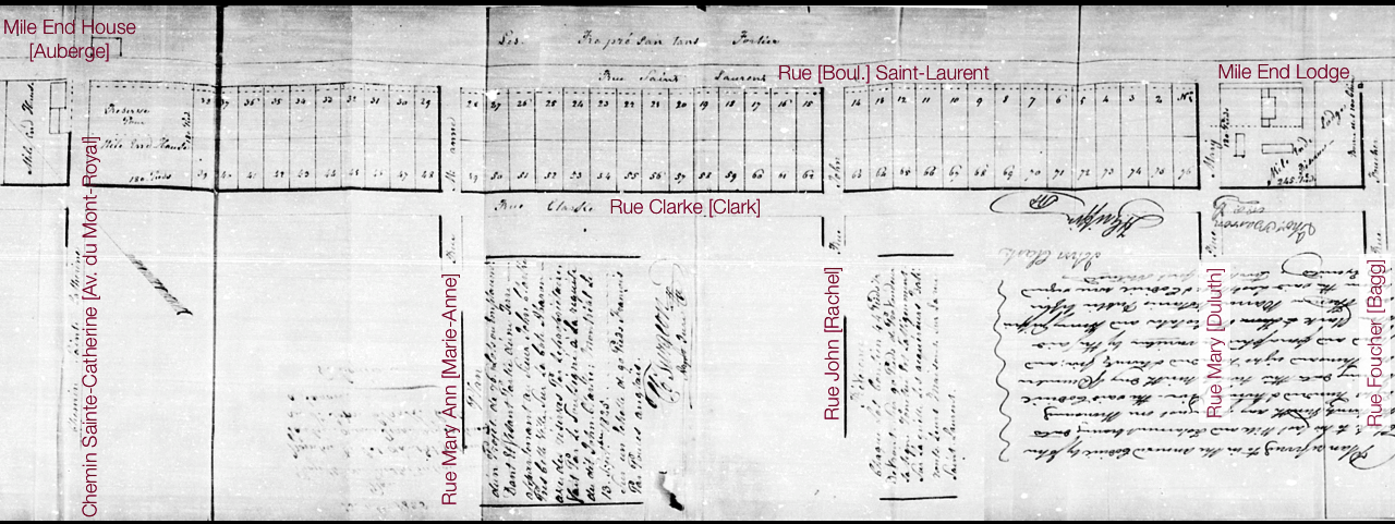
Subdivision plan of part of Mile End Farm. Codicil to the will of John Clark, December 1825. BAnQ CN601,S187
The following generations of the Bagg family imposed similar conditions on their buyers to ensure socio-economic consistency in their new neighbourhoods: “Their sales of land always required the buyer to build promptly and on a substantial scale, with stone facing, a minimum of two stories, strictly for residential occupancy, in conformity to their street plan and private design of zoning.”28
John Clark’s project was about 25 years before the birth of Saint-Jean-Baptiste village, located to the east, created primarily by French-Canadian land developers. Montreal historians often describe Saint-Laurent Boulevard as the boundary between anglophone and francophone parts of the city, as shown by this article by Alan Knight:
Contrairement à ce que certains ont pu dire, les lotissements de M. Cadieux de Courville [un des promoteurs du village de Saint-Jean Baptiste] ne sont pas tributaires du savoir-faire d’un Redpath ou d’un McGill pour la très bonne raison qu’ils ont été réalisés avant ceux effectués par ces anglophones. Ces lotissements traduisent donc tout le savoir-faire urbain d’une société inscrite depuis longtemps dans l’espace colonial. Voilà pourquoi l’enjeu du développement du village se situe autant sur le plan culturel que technologique.29
In any case, John Clark’s wish to attract a French Canadian Catholic population to the sector by offering land to build the Roman Catholic cathedral, not to mention his business relations with the Hospitaller nuns, all of which occurred well before the Cadieux de Courville subdivision, demonstrates that this border, as real as it was, was also permeable.
Excellent!
Would like to find more on the Mile-End history from the 1890 to 1940 period. Any suggestions?
Hi,
No synthesis of Mile End’s history between 1890 and 1940 has been published yet. (We’re working on it at Mile End Memories.) What we’re publishing on our web site will go, for the time being, to 1910 (the year when Montreal annexed the Ville Saint-Louis suburb). After that, we’re still in the research stage.
If you’re interested in the Jewish period (roughly 1920-1960), a lot has been published already. Pierre Anctil’s books and articles would be a good starting point.
Otherwise, keep coming back to our web site. We’re regularly adding new material.
Regards,
Yves Desjardins