The first part of the area in which farms were joined by a hamlet was at the intersection of what are now Mont-Royal and Henri-Julien avenues. It was known as the Tannéries des Bélair, named for the family that first lived there. Jean-Louis Plessis dit Bélair was born in 1678 in France, where he learned to be a tanner. In 1710, the colonial intendant wanted to end the monopoly of the families owning the only two tanneries in Montreal (the Delauneys and the Barsalous). As a result, he granted Plessis the right to pursue this trade as well. After offering his services to others for a time, by 1714, Jean-Louis Plessis had accumulated enough capital to buy land for his own tannery.1
He acquired eight superficial arpents in Coteau Saint-Louis, for the price of 600 livres. On this piece of land, where a stream flowed, Bélair had a master carpenter build a tanning mill with a water wheel. At the time Bélair set up operations, the sector was practically deserted. However, the area became more accessible with the opening by the Sulpicians in 1717 of a King’s Highway, now Saint-Laurent Boulevard, whose purpose was to improve communications with the newly established agricultural lands in the central portion of the island of Montreal.
Two things explain the choice of the site. The first is that tanneries had to be located away from the city, since the curing of hides generated offensive odours; the second, that a great deal of water was needed – a stream flowing from the mountain was located at this spot.2 The portion of the road connecting these tanneries to the city via Saint-Laurent Road, was known as the “Chemin des Tanneries”. This is now a section of Mont-Royal Avenue.
While the Plessis-Bélair family was the first to settle in the area, they did not remain alone for long. In 1742, the son, Charles, who had taken over management of the tannery, sued another family of tanners who had set up shop nearby, the Robreau dit Duplessis, for having diverted the stream that fed the family business.3
While the judge ruled in favour of Charles, his victory was to be short-lived: in 1749, he sold his tannery to another business person, Louise de Ramezay, who entrusted management to his competitor, Pierre Robreau.4 It is likely that the two families had reconciled in the meantime since Robreau married Marie-Louise Plessis-Bélair, the daughter of Jean-Louis, and the sister of Charles.5
Around 1750, Charles purchased more land near the tannery, as well as a long, narrow strip, located just west of what is now Sainte-Élisabeth Street and Laval Avenue running from the walls of the fortified city, through Faubourg Saint-Laurent to the north, climbing the Côte à Baron, to current Sherbrooke Street and beyond.6In his study of the development of the Faubourg Saint-Laurent, Alan M. Stewart indicates that the family also derived wealth from subdividing property it owned within the Faubourg.
What is certain is that by 1781, the two families were already well established in Coteau Saint-Louis.
Coteau Saint-Louis in 1781
We know this because in 1781, the Messieurs de Saint-Sulpice, seigneurs of Montreal, produced an ”aveu et dénombrement” (that is a seigneurial census, a list of properties and their owners) of their land holdings.7
The contents provide an overview of the large Coteau Saint-Louis area, which was located beyond the Faubourg Saint-Laurent of the time, extending as far as the boundaries of the parish of Montreal, near what is now Jean-Talon Street. The area is described as being shared by 20 owners, including 2 religious communities, the Demoiselles de la Charité (Sœurs Grises) and the Religieuses Hospitalières (of Hôtel-Dieu). The latter owned, in the western area, near the mountain, a property known as Terre de la Providence, or Mont Sainte-Famille, of one hundred fifty arpents, composed of thickets, uncleared land and cropland. With the exception of two orchards (one of which included a cider press), the properties of their neighbours (Dumeyniou, Lepailleur, the Caron estate, etc.) were described as made up of uncleared land, scrub and thickets. It can be concluded that at the time, the religious orders still lived within the walled city, and used these properties primarily as woodlots, not living on them. For example, a notarial act indicates that the Religieuses Hospitalières operated a lime kiln, fed with wood they had cut on their lands.8
To the east, in the area now crossed by Saint-Laurent Boulevard, the situation was completely different. The Plessis-Bélair and Robrau-Duplessis clans had eight properties and five tanneries. A hamlet had been created; in addition to the tanneries, there were also several houses, barns and stables. Known by the end of the 18th century as the “Village de la Tannerie des Bélair” this was the first village to emerge on the plateau rising above the city north of Faubourg Saint-Laurent. While it was the tanning activities that led to the birth of the village, its growth throughout the 19th century was due to another economic activity, stone quarries.

Figure 1 – The Bélair tannery was located at the intersection of Tannery Street (Mont-Royal Ave.) and Robin (Henri-Julien). The blue line indicates the stream that flowed down from Mount Royal and through the tannery property. Fortification Surveys, 1869. Library and Archives Canada.

Jeunesses Musicales of Canada House (formerly Laurier Clinic), which is located near the spot where the tannery used to be. (Wikimedia Commons)
The quarries
Coteau Saint-Louis was a source of limestone, a material quite useful for construction and the impetus for a settlement of workers and artisans who worked in the nearby quarries. Montreal greystone was to be used on most Montreal public buildings constructed during the nineteenth century. In 1823, a member of the Plessis-Bélair family offered to provide the wardens of Notre-Dame parish stone for the construction of the new church on Place d’Armes.9 These activities attract to the Coteau Saint-Louis a community of artisans and workers employed in the tanneries and the surrounding quarries. Tannery Road (renamed Carrière Street ca. 1875) continued further north, curving along the boundaries of the various quarries which were successively exploited. It is a very noticeable exception to the dominant rectangular grid that was later adopted for the urban subdivision of Plateau Mont-Royal.10
Jacques Viger, known primarily as the island’s road surveyor (1813-1840) and as the first mayor of Montreal (1833-1836), prepared many studies and reports on the city’s society and management of the time. He was responsible for an 1825 census which counted 116 residents in the Bélair village, a majority of whom were day workers. While some of the workers laboured on nearby farms, the majority worked in the quarries. Among the other trades identified, we note 5 farmers (and a ”cow park” containing 99 animals), 1 blacksmith, 2 masons, and 1 innkeeper. Viger has 24 houses, “a large tannery in stone” and noted the presence of a store.11

«Sketches in the Montreal Quarries», Canadian Illustrated News, 1877 (BAnQ)
Viger also, when he was responsible for the surveying and maintenance of public roads, provided an invaluable 1840 account of the area that was to become the eastern portion of Mile End.12
For the purposes of road management, this sector was called the Saint-Michel division, it was bisected by Saint-Michel Road, which was better known as Tannery Road (later Carrière Street). Active quarries dominated the landscape:
C’est principalement de la division St. Michel qu’on tire la pierre de taille et autres pierres à bâtisse, le sable et la chaux employés dans les constructions de la ville et de ses environs; ces belles et abondantes carrières sont même exploitées pour les bâtisses de Québec. En outre de ce roulage, pesant et destructeur, il y a encore celui, très considérable, de toutes les voitures venant du nord de l’Ile, et au-delà par la route du Sault, débouchant dans la division de la Visitation. Le sol général est ou rocheux, ou sablonneux et veule.13
The Saint-Michel territory was located to the east of another division, Sainte-Catherine with Saint-Laurent Boulevard forming the border between the two. At this location, the intersection where the east-west road serving the St. Michel and St. Catherine divisions met “the extension of Saint Laurent Street”. This busy crossroads was already called “Mile End”. Viger described the condition of Saint-Laurent Street further south in the following way:
C’est une rue extraordinairement fatiguée par le roulage le plus pesant, celui des carrières de la cité, etc. C’est le débouché de St. Michel, de St. Laurent, et de Sainte-Catherine, comme de tout ce qui vient de voyageurs des paroisses au-delà de l’Ile de ce côté, par les trois chemins sus-cités qui y aboutissent à Mile-End.14

André Jobin, Carte de l’île de Montréal (extrait), 1834. BAnQ
Later, Viger suggested assessing a tax on the quarries, and a toll on Victoria Road (today’s Papineau Avenue, opened in 1810 as a private road by the notary Joseph Papineau who financed it by selling lots along its route, and which had just been declared a public road), in order to construct a horse-drawn tramway, to haul stones from the quarry to Place de la Reine in Faubourg Québec, which became a storage site for such materials. All of this was, of course, designed to reduce congestion on St-Laurent Road.
The condition of the roads linking this village to the city was an important issue for the quarry owners. Maintenance of these roads was at the heart of Montreal governance which, as will be shown, went through several reorganizations in the first half of the nineteenth century.15
For example, the delivery of heavy loads of stones to the city on proper roads made the corvée system (repair work brigades) become completely inadequate: in 1840, the Governor entrusted the management of roads to trustees (the Turnpike Trust) which installed toll barriers to require user to pay a fee.16
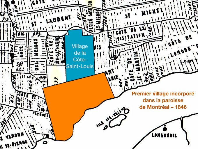
The village of Côte Saint-Louis
In 1846, the village around the Bélair tannery, together with the surrounding area, was incorporated under the name of the Village of Côte-Saint-Louis. Its residents became famous in the second half of the nineteenth century, when they were known as the “Pieds-Noirs”, as will be discussed later. As for the Plessis-Bélair and Robreau families, they owned property in Coteau St. Louis for more than a century, as evidenced by the first cadastral reference book of Montréal in 1872 and various maps kept at the BAnQ.17 Moreover, in 1991, a La Presse journalist, interviewed a resident of Mentana Street, Jean Plessis-Bélair, who proudly claimed his roots in the heart of the Plateau!18
The owners of the quarries in the Coteau must have worked hard to obtain incorporation of the village, in order to increase their control on the area. In his article on the Pieds-Noirs, Robert Prévost wrote the following:
Le nombre des familles dans les environs devint assez considérable pour que les autorités songeassent à leur donner une administration. Dans le début, le territoire fut administré par des commissaires, parmi lesquels on relève les noms de MM. Godard Lapointe, Édouard Cadorette et Jean Prénoveau, avantageusement connu à Montréal comme entrepreneur et comme possesseur de riches carrières dans la localité. Ce hameau florissant ne pouvait rester sous le contrôle des fonctionnaires et, en 1846, les chefs de famille de la localité, les Dupré, les Martineau, les Potvin, les Lapointe, etc., songèrent à l’incorporation.19
Indeed, as mentioned by Dany Fougères, during the months surrounding the creation of the village, the local governance system in the province was particularly unstable: between 1845 and 1855, in the aftermath of the Durham report, a municipal system was established, then abolished, and then re-established. The territory of the parish of Montreal around the city, was organized as one large municipality, Hochelaga, on June 18, 1845. Less than a year later, on June 9, 1846, Hochelaga was in turn subdivided into five municipalities, including La Visitation, which saw part of its territory detached – the part “commonly called Village des Tanneries de Bélair” – not even five months later, on October 14, 1846.20 This new village of Côte-Saint-Louis included the area of the Sulpicians’ Coteau Saint-Louis outside of Montreal’s city limits, augmented by a band of land between today’s Saint-Hubert Street and Papineau, up to the area including the locations of major quarries. Its boundaries were defined as follows:
The village of Côte Saint-Louis commonly called “La Tannerie des Bellaires” forming a portion of the Municipalité de la Visitation, constituted and limited by 9 V.c.78 shall have the following boundaries: to the southeast, the limits of the City of Montreal, to the southwest, the limits of the Municipality of Côte des Neiges;21 to the northwest, in part by the boundaries of the Saint-Laurent Parish and in part by the limits of the Sault-au-Récollet Parish, and to the northeast, in part by the road commonly known as Papineau Road, to the aforementioned limits of the City of Montreal, to the intersection of the Côte de la Visitation Road; and from there by a right line extending from said road, to the limits of the aforementioned Sault-au-Récollet parish.22
Village of Côte-Saint-Louis and city of Montreal, 1846.
Base map: Les côtes de l’île de Montréal, after Jean-Charles Bédard (ca. 1805) – Section d’arpentage, Travaux publics, Ville de Montréal
These new administrative divisions were short-lived. The following year, 1847, the legislature abolished all these municipalities — with the exception of the incorporated towns and villages — and replaced them with counties; municipalities at the parish scale would return, permanently this time, in 1855. Consequently, on Montreal island, only two municipalities predate 1855: the city of Montreal itself, and the Village of Côte-Saint-Louis.
Given the current state of research, we can only suggest some hypotheses as to why Côte-Saint-Louis was able to obtain and maintain its status as a municipality. The rest of the parish had already been divided into côtes and villages, yet none of them were provided with municipal incorporation. Jean-Claude Marsan explains in his classic book on Montreal’s urban development that the organization of rural land in côtes, which functioned as “neighbourhood units”23, resulted in its residents having a sense of belonging to a distinct community: “The côte … constituted the basic territorial unit responsible for social cohesion. Its spatial delineation tended to arouse the colonist’s feeling of identification with a definite territory and of belonging to a specific human community.24
But why didn’t other village communities on the island of Montréal, equally well structured, such as Saint-Henri or Côte-des-Neiges, obtain the same status as Côte-Saint-Louis?
It must have been due to the large landowners involved: with the increase in public works in Montreal, those who owned the Côte-Saint-Louis quarries enjoyed wealth and not insubstantial influence. This possibility was suggested by Dany Fougères, who wrote:
Les principaux promoteurs de l’incorporation municipale se trouvent parmi les plus grands propriétaires fonciers, lesquels voient en la corporation municipale un précieux outil politique pour l’avancement de leurs projets. Invariablement, la demande d’incorporation tient simultanément (…) d’une volonté de mise en valeur du territoire et de l’ambition de doter celui-ci d’infrastructures publiques.25
The influence of these large landowners and land developers would also increase in the second half of the nineteenth century, when urbanization reached the district: Côte Saint-Louis was divided several times due to the action of these promoters, before finally being annexed by Montreal in 1893. To understand the role played by these promoters in the development of Mile End, the next chapter will focus on two families, among the largest landowners of the district: the Bagg family on the west side of Saint-Laurent Boulevard and the Beaubien on the east.
Rev. by Justin Bur Sept. 2021; Oct. 2022
Jeeeeedelj
Je me nomme Normand Plessis Belair et mon fils Charles Plessis Belair, nous avons DES immeubles sur Le plateau et sommes heureux de connaitre ici nos origines Merci!
Remerciements appréciés ! Nous savions que la famille Plessis Belair avait été longtemps propriétaire de terrains sur le Plateau, mais ignorions que c’était toujours le cas.
Si vous détenez des informations sur vos ancêtres, n’hésitez pas à les partager ici et avec nos amis de la Société d’histoire et de généalogie du Plateau Mont-Royal.
Ce billet est superbement rédigé et présente tous les faits significatifs touchant le Coteau Saint-Louis, la tannerie et les carrières.
Merci beaucoup! Venant de vous, c’est très apprécié.