Chapter 1: Rural Mile End
A magnificent forest?
The early days of Mile End are still poorly known. In 1891, the Lovell’s directory published a promotional guide using data from the then recently completed census. In addition to articles on Montreal, the book presented brief portrayals of the outlying villages. The article on Saint-Louis-du-Mile-End fit in half a page:
Before the year 1800 the site on which the village stands was a forest, and mostly belonged to Pierre D. Bélair. An Englishman, named Mountpleasant, purchased it from the former owner, and experimented with orchard culture with a large stock of fruit trees imported from England. His attempt was unsuccessful, and the land passes into the Whitehall and Knapp families. A few years later John and Jacob Wurtele purchased a large portion of it, and in 1816 it was subdivided between Wurtele, Fortier, John Spalding, Richard Smith and others. Still later Stanley Bagg purchased a tract of about forty acres, on a portion of which the Provincial Exhibition buildings are now erected. In 1805 a clearance was made on the west side of St. Lawrence road to the brow of the Mountain, northward from where the Hotel Dieu Convent and Hospital now stands, to the present Mount Royal avenue. The clearance was turned into pasture land and a race course. The course was the only one in either Lower or Upper Canada. Robert Lovell and family, in 1820 and 1821, occupied what was then known as the Wurtele property, now almost the centre of this prosperous and progressive village, then known as the Mile End. On the outskirts are several farms, among which may be noted that of John Spalding, whose father was one of the first pioneers in this district. All this immense tract of land originally belonged to the Seminary of St Sulpice and the Ladies of the Hotel Dieu.1
Edgar Andrew Collard, a Montreal Gazette journalist who for many years wrote a column on the history of Montreal, published the memories of a Montrealer describing the area around 1840. Family names and farms mentioned partly coincide with those published in Lovell’s:
We moved out to the Mile End and lived for a time in a great big old stone house on Mr. Jacob Wurtele’s farm. It stood far from the road and there was a fine avenue of basswood, elm and poplar trees in front. Here my mother taught school. The children came in from all round. The Spaulding farm was a fine farm then, run by Mrs. Spaulding though her husband was living, but he was old and feeble. There was one son, Bill, who worked on the farm, and her son James Spaulding kept the Mile End Hotel. There was another large hotel kept by a French family, and there was a large tannery (Blair’s, I think) and Charlton’s market garden, and about a dozen houses formed the Mile End of that day. There were stone quarries; too, some old ones filled with water, fine, fresh and cool, the swimming places of all the boys around. There were broad sand pits, too, where we boys used to play and hunt for martens’ and swallows’ nests in the sand bank.2
On 25 November 1893, the French-language newspaper La Presse took its turn describing 18th-century Mile End:
En 1774, cette région avoisinant Montréal, bornée par l’avenue Mont-Royal, le chemin Papineau et […] Saint-Laurent était ce que l’on était convenu d’appeler la résidence des officiers militaires qui y avaient établi demeure. Où nous voyons aujourd’hui de belles rues bordées de demeures princières, il n’y avait dans ce temps-là qu’une forêt avec quelques éclaircies dues à la hache des ouvriers de M. Fay, un des officiers qui avait élu domicile dans ce domaine.3
The 1891 Lovell’s article is important, because it was a source for later writers on Mile End’s early rural days. For example, in 1938, historian Robert Prévost published a series of articles on the first inhabitants of the sector, nicknamed the Pieds-Noirs (black feet). Here is how he described the district.
À l’endroit où devait surgir plus tard la paroisse de Saint-Enfant Jésus ou de St-Louis du Mile-End, soit de la rue Mont-Royal en montant vers la rivière des Prairies, une forêt magnifique permettait à quelques citadins épris de chasse, de venir faire le coup de feu, et aux écoliers en maraude, de venir cueillir des noisettes ou de jouer aux ‘sauvages’.
En 1774, un officier de la milice anglaise, M. Fay, qui avait sa demeure à l’orée de ce bois, avait fait tracer quelques sentiers et abattre des arbres; cet abattage forma des clairières à différents endroits de la forêt.4
We will come back to the Pieds-Noirs later. For now, let us simply mention that the “founding story” comes up again, with a few changes, in several histories of Plateau Mont-Royal published in the next decades. Here are just two examples, separated by more than 30 years. In 1951, the now-defunct newspaper Le Canada published a series of articles on the history of Mile End:
Le territoire, couvert aujourd’hui par le quartier Laurier et ses environs et qui recèle l’une des plus fortes densités de population de la région métropolitaine, était une forêt au début du XIXe siècle. […] Et jusque vers 1830 ou 1840, il ne semble pas y avoir eu d’habitation permanente dans ce domaine qui était bien celui de la forêt. Tout ce que l’on sait, c’est qu’un certain M. Fay y avait fait pratiquer des clairières et des sentiers pour ses promenades de chasse. En 1891, le ‘Historical Report’ de Lovell apporte quelques autres précisions : le domaine était une forêt appartenant à Joseph D. Bélair avant 1800. […] On mentionne notamment la ‘Wurtele Property’ habitée, avant 1850, par des membres de la famille Robert Lovell ‘au centre du village connu sous le nom de Mile End’.5
And, in 1984, the author of the brochure Le Plateau Mont-Royal au 19e siècle wrote:
Au sommet de la côte à Baron s’étendait une magnifique forêt. Cette dernière permettait à quelques citadins épris de chasse de venir faire le coup de feu contre le petit gibier, et aux écoliers de venir cueillir des noisettes. Avant 1800, le site sur lequel s’est développé Saint-Louis du Mile-End appartenait en grande partie à Pierre D. Bélair. Ce dernier vendit une partie de son domaine à un anglais nommé Mountpleasant qui tenta d’y planter sans succès des arbres fruitiers importés d’Angleterre.6
This “founding story” even appears in contemporary official documents of the City of Montreal:
L’ensemble du territoire aujourd’hui nommé Mile End appartenait, avant 1800, à Pierre D. Bélair. Au cours du XVIIIe siècle, cette terre fut cependant concédée à plusieurs grands propriétaires, dont les Whitehall, Knapp, Wurtele, Spalding, Bagg et Beaubien. Ces grandes propriétés furent un facteur de ralentissement du développement.7
While the history of some of the families mentioned in Lovell’s can be traced – the Baggs, and the Bélairs, for example, other major landowners, who also strongly shaped the Mile End district are not even mentioned and their names have fallen into oblivion. For example, the English butcher, John Clark, and the widow Agathe Perrault-Nowlan, whom we will present later.
First Nations presence, colonization and clearing
But first of all, was pre-1800 Mile End really covered by the forest and bucolic clearings described by these writers? A noteworthy map drawn in 1702 by the Sulpicians, seigneurs of Montreal, provide important clues. They took over land management on the island in 1663. Taking advantage of a lull in the Iroquois wars at the end of the 17th century, the Sulpicians launched a vast operation to colonize the rural areas outside the boundaries of the walled city. They granted land in long, narrow strips of property perpendicular to the shores of the island of Montreal within groupings referred to as côtes (“coasts”, ”shores”).8
")
Figure 4: Description générale de l’île de Montréal, François Vachon de Belmont, 1702 (extrait). From Jean-Claude Robert, Atlas historique de Montréal, Libre Expression, 1994, p.43. The winding road that starts at the town, skirts the mountain and leads to Sault-au-Récollet was a First Nations trail.
Archaeologist Brad Loewen has reconstituted the portrait of the original forest over a period of about 350 years, based on the Sulpician map and an analysis of written accounts left by the first European visitors to the island, Cartier and Champlain.9 While centuries of First Nation use, due to their hunting, gathering and extensive agricultural activity (slash-and-burn), had considerably modified the southern and western parts of the island, this was not the same for the centre, which remained relatively intact:
La première zone, qui contient la forêt la plus ancienne, est une immense cédraie, longue de 25 km et large de 5 km, qui domine le versant nord-ouest de l’île, au nord du mont Royal. Elle s’étend entre ce qui est aujourd’hui la carrière Lafarge à Montréal-Est et l’aéroport de Dorval dans l’ouest de l’île. […] Selon les principes de succession forestière, la grande cédraie constitue une forêt finale et elle existe à cet endroit depuis plusieurs siècles.10
Loewen added that near Mount Royal, where Mile End is located, the cedars gave way to another species, the ash.11 However, if this extensive forest of cedars and ash trees was still intact in 1702, the situation did not last very long after new lots were granted. Historian Louise Dechêne has demonstrated that the habitants’ need for firewood, given the rigours of Canadian winters, meant that progressive clearing was very rapid.12 Even before new land concessions were made along the côtes in the interior portions of the island, the need to heat the buildings of Ville-Marie had already created a vast deforested area to the south: «cette zone entoure la jeune ville et s’étend jusqu’au pied du mont Royal. […] À l’est du mont Royal, elle remonte le versant sud de l’île jusqu’à l’axe des actuelles rues Fairmount et Masson, à moins d’un kilomètre de la crête centrale de l’île».13 Loewen notes:
Environ le tiers de la superficie totale de 499 km2 de l’île est déboisé depuis la fondation de Montréal. […] Chaque année, la forêt perd en moyenne 2,78 km2 de sa superficie et plus de 50 000 de ses meilleurs arbres, à la faveur des cultures, des pâturages et des constructions.14
This means that the “magnificent” forest untouched by habitation, as mentioned in the previously cited accounts, falls within the realm of mythology by the second half of the eighteenth century. As documented by Joanne Burgess and Claire Poitras, human activity had already greatly changed the natural landscape of the plateau:
En 1780, près d’un siècle et demi après la fondation de Ville-Marie, les interventions humaines ont transformé profondément le mont Royal. Ses trois collines ont été encerclées entièrement par les exploitations agricoles. L’activité paysanne a fait progresser les défrichements et, aux abords de la montagne, les boisés d’origine ont reculé au profit des champs de céréales. Un habitat rural prend forme le long des chemins de desserte : maisons de pierre, bâtiments de ferme, potagers et vergers.15
In his study, Loewen gives the stages of this transformation: until 1698, the mountain and adjacent territory on the east were reserved for First Nations that had joined the Sulpician mission, enabling them to maintain a traditional subsistence life (hunting, gathering, agriculture). After their expulsion, these lands were granted along the côtes «à travers la grande cédraie. Le chemin desservant les nouvelles fermes suit l’axe central de la cédraie, qui, lui, est déjà défriché. Soustraite du domaine seigneurial, la cédraie est donnée entièrement aux censitaires afin de subvenir à leurs besoins de construction et de chauffage.»16 Between 1830 and 1870, the sector was partially reforested, concluded Loewen, with apple orchards planted between Sherbrooke Street and Pine Avenue: «après deux siècles de déboisement continu, c’est la première plantation importante d’arbres à Montréal.»17 Further north, in what is now Mile End, pastures and vegetable crops dominated, as will be discussed later.
Fields, pastures, orchards, and a race course
Two images from the early 19th century show the extent of human intervention. The first, a watercolour entitled Montreal from the race course on the mountain, was painted circa 1821 by John Elliott Woolford (figure 5). The second by John Duncan, View near Mile End, Montreal, dates from 1831 (figure 6). Woolford painted the view from the slopes of Mont-Royal; the city is still largely contained behind the fortifications of the eighteenth-century walls. St. Lawrence Road pierced the walls, climbing the Côte-à-Baron (indicated by a mill on the left not far from what is now Saint-Denis Street), and partially bordered by a few country cottages. The pavilion on the bottom left is surrounded by the race track mentioned in the title of the picture and also mentioned in the 1891 Lovell’s article. Located between what is now Park Avenue and Saint-Laurent Blvd, the race track was laid out in 1811 by Stanley Bagg, on land leased from his future father-in-law, the prosperous English butcher John Clark. Together with the Soeurs Hospitalières de Saint-Joseph, Clark was one of the main property-owners of the land north of Sherbrooke Street, from the slopes of Mount Royal to Saint-Lawrence Road.
The second picture was drawn 10 years later from the opposite point of view. A man and his dog walk along St. Lawrence Road on the east side, probably south of what is now Duluth Street. While the Saint-Laurent suburb extending to Sherbrooke Street has grown considerably denser since 1821, pastures and country homes still dominate the landscape of the plateau, as confirmed by an another watercolour by Duncan, painted the following year (figure 7). Duncan also painted a View of Montréal showing Hôtel-Dieu around 187018 – a time when cows still grazed on the mountain.

Figure 5: John Elliot Woolford, Montreal from the mountain, on the race course, ca. 1819-1821
National Gallery of Canada (23416)
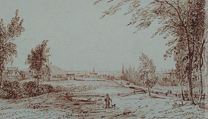
Figure 6: James Duncan, View near Mile End, Montréal, 1831 – McCord Museum
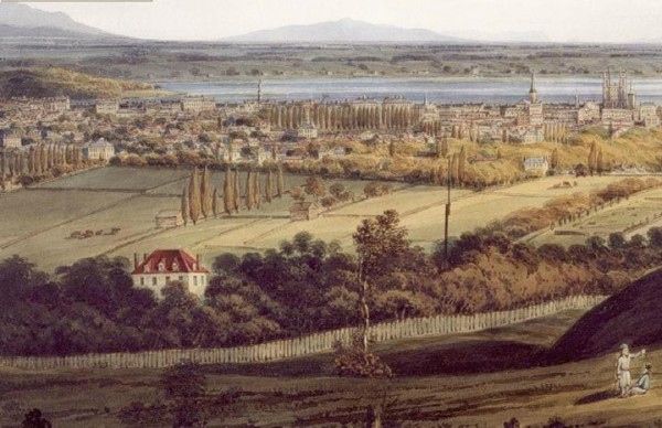
Figure 7: James Duncan, Montreal in 1832 (fragment). In the foreground can be seen “Piémont”, built in 1820 for politician Louis-Charles Foucher. This villa is a representative example of development west of St. Lawrence Road. – McCord Museum
The map below (figure 8) shows the spatial organization of the area in long narrow bands along the côtes still remained in 1879, even if urbanization had taken shape to the south, on the east side of St. Lawrence Road (in the municipalities of Saint-Jean-Baptiste and Côte-Saint-Louis). To the west, only the eastern and southern parts of Saint-Louis du Mile-End had developed, principally along St. Lawrence Road. In fact, as we will see later, most of the streets and avenues indicated in the Hopkins atlas on the property of “Peter [sic] Beaubien” – between St. Lawrence and the land of “G.G.A. Compte” – only existed on paper.

Figure 8: Hopkins atlas, 1879 (excerpt) – BAnQ
The first villages
A series of photographs show what Mile End looked like about 30 years after Duncan’s watercolour. The first (figure 9), taken from the roof of Ravenscrag, Sir Hugh Allan’s home which now houses the Allan Memorial Institute, provides a panoramic view toward the northeast. It shows Hôtel-Dieu in 1869, shortly after its construction. Except for a few houses along St. Lawrence Road (in the middle, left of the hospital), the environment was still covered by trees and fields: Park Avenue has not been laid out yet between the line of trees and the walls of the hospital.

Figure 9: James Inglis, View of Montreal from Ravenscrag showing Hôtel-Dieu, panorama, 1869 – McCord Museum
The next image (figure 10),19 taken about a decade later, was photographed from a lower point of view and further north, approximately in line with Marie-Anne Street. The purpose was to show the so-called Crystal Palace, moved in 1878 from its original location on Saint-Catherine Street to the site of the provincial agricultural fair, located just to the north of Hôtel-Dieu. The Crystal Palace is the barrel-vaulted structure visible on the far left of the photo, at what is now the intersection of Esplanade and Saint-Joseph. The primary importance of this image is the fact that it is the oldest known photograph showing the village of Saint-Louis-du-Mile-End. The first version of Saint-Enfant-Jésus Church, located on Saint-Laurent between Laurier and Saint-Joseph, can be seen in the background in the centre of the photograph. The entire western sector was still rural, as indicated in the Hopkins atlas: a vast, apparently empty space, above the Agricultural Grounds, divided between two properties, the “Nolan [sic] Estate” and “R.S. Bagg”, as well as an enclave, located just above the fair grounds, belonging to the Soeurs Hospitalières.

Figure 10: Saint-Louis-du-Mile-End, ca. 1878-1880. Reproduced in Bryan Demshinsky, Montreal then and now, The Gazette, 1985, p. 92 (photographer unknown)

Figure 11: Montreal Hunt Club at Mile End Road, near Montreal, 1859 –
McCord Museum
A well-known 1859 photograph provides another view of the sector: a view of what is now Mont-Royal Avenue, at the corner of Saint-Laurent. The mountain is visible on the horizon and a line of poplars frames the road leading to it. On the right can be seen the corner of a stone building. This is the only known photograph showing the Mile End Tavern.
The Perrault survey: an avenue amid farmland
One of the most precise sources about Mile End just before it urbanized is provided in a surveyor’s plan by Henri-Maurice Perrault, circa 1880. Architect and land surveyor (he laid out the large properties in the “Golden Square Mile”), Perrault was also one of the trustees of the Nowlan Estate, the extensive holding that included parts of Outremont and Saint-Louis du Mile End shown in the Hopkins atlas. His was the first urban subdivision project of this undeveloped land. The completion four years previously of the Quebec, Montreal, Ottawa & Occidental Railway, which cut across one end of the Nowlan Estate and included a station located a short distance to the east, was probably a factor in the creation of this plan. Perrault proposed the extension of Bleury Street – at that time just a dirt road ending at Mount Royal Avenue – into a 70-foot wide avenue extending northward, and the subdivision of adjacent properties into building lots. A parallel street, which was to become Hutchison, was also planned, as were those that later became Saint-Joseph, Fairmount and Bernard. The plan shows the prior existence of two farms (with one farm’s main building dating to 1798). Their removal would be necessary, as was elimination of a pond. A stream flowing eastward from the mountain corresponds to what later became Groll Street. However, for reasons that will be discussed later, no progress was made on this plan for another decade.
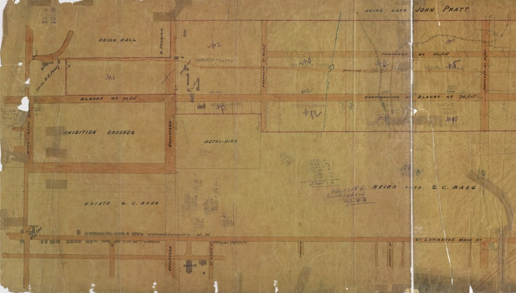
Figure 12: Plan of properties situated at Mile End (excerpt). Attributed to Henri-Maurice Perrault, ca. 1880. BAnQ CA601,S53,SS1,P1316. In the lower right, “St. Lawrence Main Street”. Saint-Enfant-Jésus Church can be seen in the lower centre. Between the church and the place known as “Mile End”, where the hotel and tavern in the 1859 photo was located, can be seen several wooden village houses. Apart from the “Exhibition Grounds” and a rectangle belonging to the Hôtel-Dieu nuns (in the middle of the plan), all the land below the red line belonged to “Heirs late S.C. Bagg”. The Nowlan property, with the proposed streets and subdivision, is above, surrounded by the property of “Heirs late John Pratt”, “G. Tessier”, “Heirs Hall” and “Heirs E.G. Penny”. The farm buildings to be demolished are in the right-of-way of “Boulevard” and “Continuation of Bleury St.” The stream and the pond are to the right of these buildings. On the part of the plan not reproduced here, more farm buildings are indicated to be demolished for new streets, north of the future Bernard Street.